Share:
Want A Clearer Picture Of Your Waterbody?
Schedule a professional GIS mapping with TIGRIS today!
Water bodies like ponds and lakes are often enhancements to your landscape that offer a peaceful escape. However, maintaining the health of these water bodies is far more complex than it may seem at first glance. Whether you’re a property owner, manager, or environmental professional, understanding the spatial distribution and condition of your pond or lake is essential to its long-term health and usability.
That’s where GIS-based water body mapping comes in, and why it’s so important.
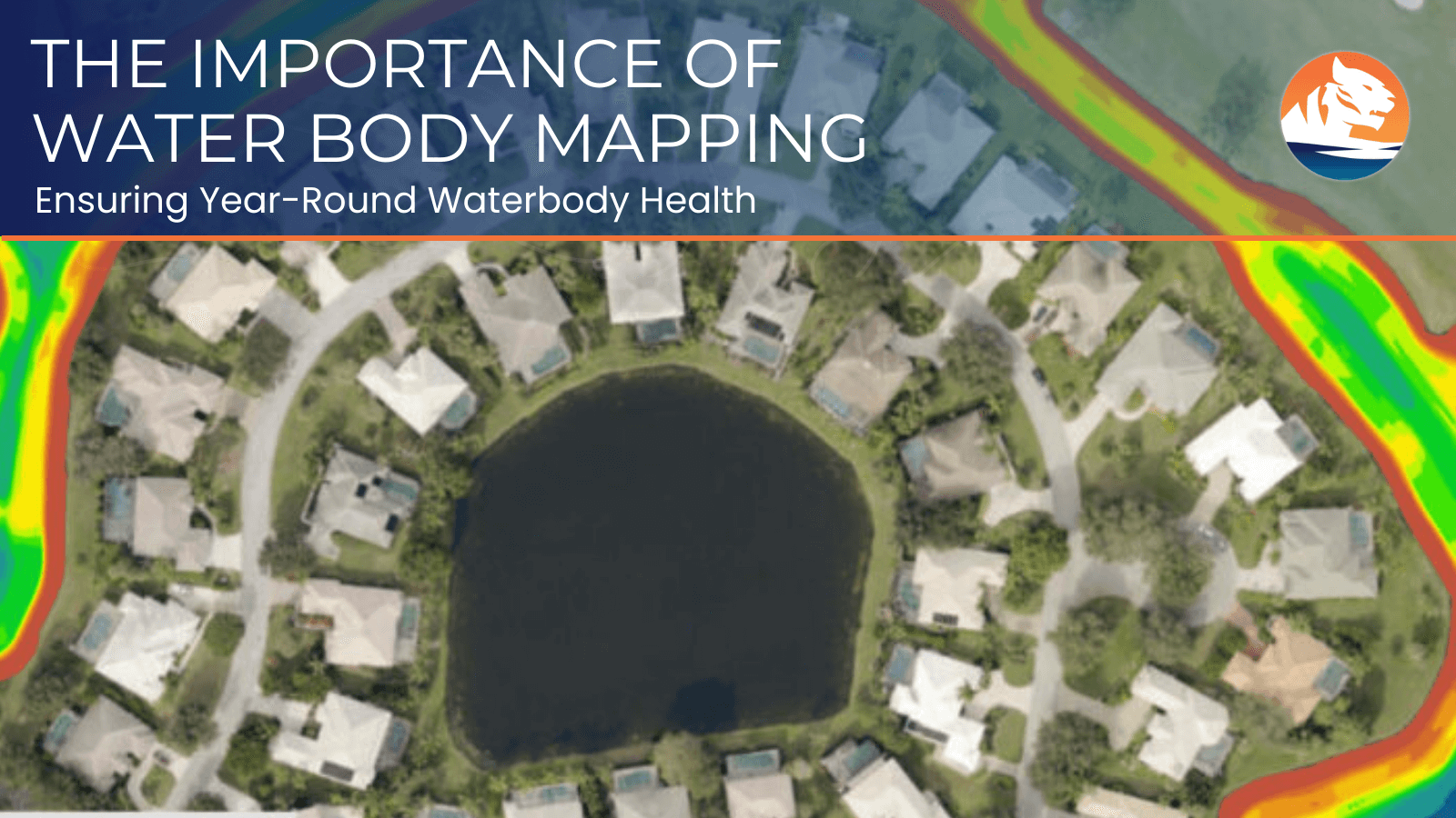
What is water body mapping?
Water body mapping is the process of using Geographic Information Systems (GIS) technology to analyze and create detailed spatial maps of ponds, lakes, and other water bodies. This mapping integrates multiple data sources, including bathymetric surveys using sonar and GPS, remote sensing imagery, water quality sampling with georeferenced locations, and aquatic vegetation assessments, to build comprehensive spatial layers. The result is an interactive map that shows not just individual measurements, but the spatial relationships between water depth, sediment distribution, aquatic vegetation patterns, water quality parameters, and potential contaminants across your entire water body.
Why is water body mapping important?
1. Assessing Water Quality Spatially
Water quality is the foundation of a healthy aquatic ecosystem. While point samples tell you conditions at specific locations, GIS mapping reveals spatial patterns across your entire water body. By mapping pH levels, dissolved oxygen, temperature, and nutrient concentrations, you can identify zones of concern, such as areas with low oxygen near the bottom or nutrient hotspots that may trigger algae blooms. This spatial perspective allows you to track these variables over time and understand how conditions vary throughout your water body, ensuring targeted management strategies.
2. Identifying Potential Problem Areas
Water bodies are dynamic ecosystems where sediment buildup, nutrient overloads, or invasive species may alter the balance over time. GIS mapping excels at spatial analysis that reveals problem areas invisible to traditional monitoring. For example, overlaying depth contours with vegetation surveys can identify where excessive sediment accumulation is reducing water depth, while spatial modeling can predict where poor circulation may lead to oxygen depletion. This early identification through spatial analysis allows for timely, location-specific intervention rather than whole-pond treatments.
3. Improving Ecosystem Management
GIS-based water body mapping allows you to understand the spatial distribution of plant life, aquatic habitats, and species populations across your water body. By creating detailed habitat maps that show zones of varying depth, substrate type, and vegetation density, you can identify where excessive plant growth is occurring or where habitat diversity is lacking. This spatial approach helps you target invasive species removal efforts, plan native plantings in optimal locations, and maintain natural balance, ensuring a thriving, biodiverse aquatic environment.
4. Supporting Regulatory Compliance
For property owners or managers responsible for maintaining water bodies, local and state regulations may require you to document water quality, wetland boundaries, and ecosystem health. GIS mapping provides standardized, georeferenced documentation that agencies recognize and accept. Spatial data can be easily shared with regulatory bodies, demonstrates your stewardship efforts, and helps you stay in compliance with environmental standards such as Clean Water Act requirements or local watershed protection ordinances.
5. Planning for Future Enhancements
If you’re considering improvements to your pond or lake, such as installing aerators, dredging accumulated sediment, adding aquatic plants, or building a dock, GIS mapping provides the spatial intelligence to guide those decisions. By analyzing depth contours, you can determine optimal aerator placement for maximum circulation. Sediment distribution maps identify where dredging is most needed. Spatial suitability analysis can pinpoint the best locations for structures based on depth, substrate, and ecological considerations. Understanding the current spatial state of your water body ensures that future enhancements are strategically placed to improve functionality, aesthetics, and ecological health.
How TIGRIS Can Help
TIGRIS provides advanced water body mapping services to help you get a complete picture of your pond or lake’s condition. Our expert team uses state-of-the-art technology to survey and map your water body, providing you with detailed reports and actionable insights.